Wednesday, July 6, 2011

QUEBEC

CHATEAU FRONTENAC, OLD QUEBEC CITY


EASTERN CANADA JOURNEY OF DISCOVERY


QUEBEC
JUNE 28 - JULY 2
RIVIERE HART JAUNE
Our next night was spent, regrettably, at Relais Gabriel, a half-way truck stop that was without question the worst place of the entire trip.  Our tiny un-airconditioned room was on the stifling hot second floor.  We had only one small window that provided little ventilation and the bathroom was shared with 5 other rooms of truckers.  Below was a small restaurant which had bug coils burning in a vain effort to repel invading hordes of black flies and mosquitoes.  Everyone smoked, probably in self-defense against the biting flies.  Nearby was a small lake, which we fled to and sat on a neatly placed bench to give ourselves some space and fresh air.  It was evening and the lake was perfectly calm and peaceful.  The only noise was the buzzing bugs around our heads which hopefully our repellent would dissuade from dining on us.  A common Loon snorkeled its way along, occasionally diving for fish.  Two Common terns flew around, circling the pond and fly-catching!  It was the first time we had ever seen this behavior from terns.  A beaver quietly worked the corner of the pond near its lodge and then swam back and forth before us, silently pushing through the quicksilver water.  Black flies snuck up my pants legs, sat on the tops of my socks and ate their way around, like my legs were a lazy susan.  These little buggers inject an anesthetic as they chew, so you feel nothing until the incredible itching commences moments later.  We returned to our hell-hole.  It was dusk now and we had the lights on.  Suddenly, we both started itching on every area of flesh that wasn’t covered.  A veritable horde of extremely tiny gnat-like biting flies had entered the room through the screen, flies so small that we could barely see them.  They made black flies look like giants.  Despite insufferable heat, the itching was so severe and the flies so numerous on the wall, we had to close the window and keep the door shut.  I thought I would go crazy for lack of oxygen.  We spent a half hour chasing down over 200 of these wretched biting mites and squashing them on the walls. We then turned off the lights, wrapped ourselves in sheets and tried to sleep in our twin beds.  About 11:00 PM, I woke in a panic, feeling like I was suffocating.  At least the flies had stopped biting.  Gas was $1.66/litre, the highest of the trip.  We sped away as fast as we could.
MANIC CINQ DAM
About 30 miles south is Manic Cinq, named after the fifth monster dam placed on the formerly monster Manicouagan River, which like its cousin to the north, has been reduced to a trickle after water is diverted for hydro-electric purposes.  We ruefully noted that there was a much nicer looking motel there and wished we had stayed there instead.  The road was extremely dusty and not in the best shape.  If you could take your eyes off the road for a moment when a dust cloud of a tractor trailer wasn’t bearing down on you, the Manicouagan area is exceptionally beautiful, with mountains and valleys and has been designated a World Biosphere Reserve by UNESCO.  The road is now paved, but not easy driving, since it winds up and down and around almost endlessly, coming to its conclusion in Baie-Comeau.  Route 389 was definitely our least favorite drive of the trip, mostly due to the heavy truck traffic.
GARDEN OF THE GLACIERS CENTRE
SEASHELL VALLEY
SEASHELLS FROM GOLDWAIT SEA
Five hours after starting, we reached Baie-Comeau on the north shore of the St. Lawrence River.  Our destination was the Garden of the Glaciers (www.jardindesglaciers.ca) a remarkable new multi-faceted project.  The primary focus is on the effects glaciers had on the geology and aboriginal peoples of the region and the effects of climate change.  The project is headquartered in a beautiful church converted into a display center, all overlooking the mighty St. Lawrence.  In addition to the exhibits and shows featured in the main building, the Garden of the Glaciers offers tours to Seashell Valley. Here the ancient glacially created Goldwait Sea deposited seashell layers up to 50 feet thickb from 30 plus species of mollusks.  You can also take a ride through the forest where native dwellings from glacial times are recreated.  Finally, along the river, for family fun, they offer “Adrenaline Park”, with five zip-lines on the cliffs, rock-climbing, kayaking and a multitude of other activities.  The staff was extremely helpful, enthusiastic and informed.  We planned a one-hour visit and stayed four.
HOTEL TADOUSSAC
READY IN OUR IMMERSION SUITS
WHALE WATCH BOATS
Next stop was two hours southwest in Tadoussac, at the mouth of the Saguenay River and Fjord.  We arrived at the Hotel Tadoussac around 9:00 PM, with just enough light to see this grand old hotel, dating from 1864.  Although old, the hotel is thoroughly modern and offers excellent services, including two highly rated restaurants featuring regional cuisine.   Due to its location at the confluence of the deep Saguenay River and the even deeper trench of the food-rich St. Lawrence River, Tadoussac is one of the finest marine mammal observation sites in the world.  In addition to having an excellent marine mammal interpretation centre in the harbour, numerous operators offer guided excursions out on the St. Lawrence for a chance to see the whales that come here from the ocean to feed every summer.  Visitors can chose from a small to medium size zodiac boat for a three hour trip or for something more stable, up to a three-level whale-watch boat that was the largest I have ever seen.  When we awoke, it was raining.  We ate a big breakfast, with bacon and lots of coffee, confident that the boat would not go out in these conditions.  The rain slowed down.  The zodiac we (I) had chosen was going.  So were we.  We met at the nearby dock of Crosieres AML (www.croisieresaml.com/en), donned our warm and protective life-saving immersion suits and boarded the zodiac, with about 20 others.  It was raining lightly.  As we got out into open water, the waves increased and this type of boat just bounces with them.  Gale and I do not have stomachs or inner ears that tolerate much bouncing.  All I could think was, “What have you gotten us into?”  The waves and the rain increased.  A minke whale surfaced.  Who cares?  Just take me back to shore.  Then a miracle happened - the rain increased, but the waves diminished.   I could stop thinking about how I would be able to turn around and hang over the edge of the boat to puke without falling out.  We were not going to die.  Two fin whales surfaced nearby.  At about 60-70 feet long, the second largest mammal in the world, they dwarfed our puny boat.  Minke whales were everywhere, including one that did a 75% breach only 50 feet away, showing its pink striated underside to perfection.  A few gray seals stopped by to check us out.  Great!  Now get us the hell out of here.
MINKE WHALE
WHEELS AT THE CHEESE MUSEUM
Once again on terra firma, we were still pretty wobbly.  We had to get to Quebec City, about a three hour drive.  But since when is a three hour drive REALLY a three hour drive?  Never, when you stop to check out interesting places.  And how could you pass up The Cheese Museum in the Charlevoix Region?  We bought a little piece of Swiss cheese and then an ice cream cone that started up a conversation with Robert Benoix, chief guide for this fascinating place.  Turns out we both love photographing birds and after a little while of that topic, he offered to show us the works of the cheese factory.  We received the full cook’s tour, including explanations of how cheese is made here completely from natural ingredients, without consuming any natural resources other than milk.  When cheese is made, the process throws off methane gas, which they capture to fuel their operation.  The mud that is another byproduct is returned as fertilizer to the local farmer’s fields.  Water that is used is naturally filtered by vegetation within the factory greenhouse in several different stages until it can be returned to the rivers in a pure, clear state.  Check it out: www.fromagescharlevoix.com.


OLD QUEBEC CITY
CHANGING OF THE GUARD AT THE CITADEL
GATE TO THE OLD CITY
OLD QUEBEC
THE FUDGERIE
What can I say about Quebec City?  Charming, sophisticated, old world style, rife with North American history, beautiful in almost every way.  We checked in at the Hilton and were delighted with the view from our room, overlooking the old walled city, the citadel, the world-famous Chateau Frontenac, the elegant Quebec Parliament building, Ile d’Orleans and the St. Lawrence River.  Quebec City was the first French settlement in North America, founded in 1608 by Samuel de Champlain.  Our guide for the day was Michelle Demers, from Quebec City Tourism.  Michelle drove us around the outside of the Old City, explaining the history of the area from earliest times.  We visited the battlements of The Citadel, fortunate to catch the changing of the guard.   Passing through the St. Louis Gate, we wound through the narrow twisting streets within the walls before we abandoned the car and wandered on foot through the sights and sounds of Old Quebec.  Lunch was at a quaint little bistro, where delicious soups, pastries and sandwiches on croissants provided excellent fare.  There are superb restaurants of every type throughout the Old City and I could pleasantly imagine an effort to eat one’s way through them all.  Of course, you may not be able to fit though one of the gates leaving the city, but c’est la vie.  The streets were full of people as this was Canada Day weekend, similar to our July 4th celebrations.  Flowers seemed to drip from every establishment and upper floor window box, and since the sun was actually shining, this was indeed a festive occasion.  One of our most interesting unplanned visits was to an exhibit beneath the Our Lady of the Victories church, where Champlain in 1624 built the first permanent house by Europeans in North America.  An extensive archaeological dig in the 1970s produced many original artifacts from this period and they were first placed on display only two days before our arrival.  
DINERS IN OLD QUEBEC
We spent a couple of hours visiting the Ile d’Orleans, an island the size of Manhattan just downriver from the city.  Famed for its fine produce and family owned farms, vineyards and orchards, we enjoyed sampling some outstanding ice wine and ice cider, not to mention the fresh strawberries sold from roadside stands.  Every merchant we met was charming and happy to chat.  I would strongly recommend anyone who visits Quebec City to also spend a day or two on the island.  There are several gites (B&B’s), excellent restaurants and even two golf courses.
FIREWORKS ON CANADA DAY!
Since it was a pleasant evening after Michelle dropped us off, we went out for dinner along Rue St. Louis, an old and interesting neighborhood outside the walls and a great place to dine away from all the tourist spots within the old city.  It was an easy stroll back  through the gates and we enjoyed our aimless wandering until near dark.  Since this was Canada Day, fireworks were in order.  The show was on The Plains of Abraham, above the cliffs where Americans made a surprise attack on the Old City in 1775.  Fortunately, we were able to watch the entire show from our hotel window.
OLD CITY IN EARLY MORNING
Our last morning.  We arose early and before breakfast walked through the Old City.  Much to our surprise, no one was out before 8:00 AM and we had the place to ourselves.  The quiet and peacefulness was in stark contrast to the crowded party atmosphere that lit up the streets last night.  We saw that there are dozens of boutique hotels scattered throughout the Old City, many on little-traveled side streets.  I think if we were to return, that is where we would stay, to fully immerse ourselves in the charm of the place.  There are numerous museums and other attractions we would like to have experienced, but that is for another trip when we have more time.  For now, our trip is over but for an 8 hour drive back to Connecticut.  Au revoir, mon ami!

EAT MY DUST

Questions?  Write sam.fried@live.com 

Tuesday, July 5, 2011

LABRADOR (PART 2)

TENNESSEE WARBLER


EASTERN CANADA JOURNEY OF DISCOVERY
LABRADOR (PART 2)
JUNE 26-28
We went a birdin’ the following morning and without any real sense of the area, our game plan was a crapshoot,  After several false starts, we found Grove Point Resource Road, a small dirt track that wandered through the mixed forest.  There were tons of birds singing, including Northern Waterthrush, Black-throated Green, Yellow-rumped, Blackpoll, Tennessee Warblers, Least Flycatcher, Swainson’s Thrush and even a Mourning Warbler, well north of its normal range.  A close inspection of the range maps in Sibley’s Field Guide to Eastern Birds shows a tiny pocket of neo-tropic migrants that breed in the Churchill River Valley, due to its slightly more temperate climate and resultant variety in habitat.

We continued to explore the Happy Valley/Goose Bay region and drove 20 miles northeast to the villages of North West River and Sheshatshin.  Many native Inuit and Innu people live here and the excellent Labrador Interpretive Centre chronicles both the ancient and modern history of these peoples, commemorating their culture and traditions.  From its high vantage point, it’s also the best place in the area to view Lake Melville and Grand Lake, with a distant look at the snow-covered Mealy Mountains to the southeast.  In the afternoon, we played a quick 9 holes at Amaruk Golf Club in Goose Bay, where the greens were as shaggy as deep pile carpet.  A croquet mallet was more appropriate than a putter.  When their power cart had a flat, two young golfers decided to walk - but couldn't abandon their large cooler of beer.  Rather than play "dry", one grabbed a pull cart and strapped on the cooler while shouldering his clubs.  That's a northern dude who takes his beer drinking seriously.
BLACK-BACKED WOODPECKER FEEDING CHICK
FEMALE BLACK-BACKED DRUMMING
With a full tank of gas, we turned our sights west toward Churchill Falls, about 200 miles down the friendly dirt and gravel Route 500.  While still on the even more friendly pavement near town, a Black-backed Woodpecker flew across the road.  I quickly did a U-turn and found the bird sticking its yellow-crowned head out of a nest hole!  We spent a delightful hour watching the male and female flying back and forth to the nest, bringing a mouth-watering array of grubs and other insects to stuff sideways into the protruding little beaks.  Each time an adult approached, a whirring crescendo echoed from the hole.  When an attending parent desired the other to switch positions, it flew to the top of the dead snag in which the nest was located and drummed out a message, “Come home.  I need to get away from the kids.”  A trio of Boreal Chickadees, nattily dressed in brown and gray, toured the site, whistling their wheezy “chick-a-dee” song for added entertainment.
BRUNO THE BEAR
We continued to drive slowly, looking for wildlife and were soon rewarded by black bear number six for the trip.  Bruno was feeding on some fresh willow catkins in a low area near the road, using its massive clawed paws to pull the tender shoots toward a heavily toothed mouth.  We sat in the car, windows down, watching the nearby show.  Then the bear decided it was bored and would like to reverse roles with a thorough investigation of us.  Windows up, as Bruno came up the embankment and approached the SUV.  It disappeared in front and I suspected it was licking the front grill’s ample supply of battered bugs.  I was in the passenger seat as the bear came around, stood up and put its paws and wet nose on the window.  I never felt threatened, or that the bear was anything but curious.  Gale was in the driver’s seat and began laughing loudly when she looked in the rear view mirror and the bear was spread-eagled on the rear window with a hapless look on its face.  “How do I get into this thing”, it seemed to be thinking.  “These people look harmless and they must have some good stuff to eat in there.”  Moments later, Gale got the face-to-face treatment, as the bear stood up at her window and longingly gazed in as it slobbered all over the glass.  By now, I was laughing so hard I barely managed to take a picture.  Finally, its curiosity satisfied, Bruno ambled off and we cautiously proceeded.
I tried my hand at fly-casting one last time, as it turned out, in a lovely roadside stream that burbled and gushed between boulders, through pockets and eddies and beneath alder overhangs.  How could a giant trout not be here, waiting for my perfectly presented offering?  One six-incher with a Napoleonic complex agreed, but that was it.  After it started raining, I jumped off a rock, went in over my boot tops, filling them with ice water and decided to call it a day.  The black flies and mosquitoes greatly appreciated my exposition of bare skin as I poured out my boots and stripped down for dry clothes.
CHURCHILL FALLS AND GORGE
Churchill Falls was a strange place.  Built as the company town to support the largest underground hydro-electric plant in the world, it resembles an upscale military base.  All the buildings basically look the same, except the Town Centre, which has a hotel, Midway Travel Inn, (www.midwaylabrador.ca), restaurant, grocery store and meeting areas.  Nearby is the hydro plant, which offers free tours to its giant underground generators and turbines.  Water to run the plant is diverted from the nearby Churchill River, which formerly was a raging torrent with a massive 245 foot high waterfall.  The riverbed has been more-or-less empty and the falls a trickle of spring run-off since 1971, when the plant opened.  We crossed the Brinko Bridge and hiked a path that follows the edge of the river’s massive gorge.  The views of the former falls were amazing, but sad.  I felt like I was looking at the skeleton of a former body-builder.  We continued along and had to stop for a construction site.  All of the road crew were wearing net hats and gloves for protection against the insects, which seemed to now be reaching full force.  
HARLEQUIN DUCKS
Over the entire route, and especially as we drive past endless lakes, ponds, rivers and streams, I am amazed at the scarcity of birds, especially waterfowl.  In other regions I have traveled in the north, every pond has at least one pair of breeding ducks or loons.  Here, there are virtually none except for a handful scattered widely across the vast terrain.  On one large river, just downstream from the bridge, a pair of Harlequin Ducks slept peacefully on the rocks, safe from all predators.  Perhaps we are not far enough north to reach their breeding grounds?  Too far east?  One memorable sighting was a pair of Lincoln’s Sparrows, first described for science by John James Audubon on his 1832 visit to Labrador.  
FERMONT IRON ORE MINE
Our next destination was Labrador City, which at 9,000 folk is the largest and fastest growing town in Labrador.  The heart and soul of the city is iron ore mining, without which the city would not exist.  Founded in 1961 by what is now the Iron Ore Company of Canada, the mines here are the largest open pit iron ore sites in the world and they are rapidly increasing capacity at present.  Keeping the large view in mind, remember that we are in some of the most pristine sub-arctic wilderness in the world.  In the middle of it is this humongous array of open pit mines, running 24/7 for the last 50 years, tearing down mountains, ripping open the earth, spilling cubic miles of tailings in every direction, turning the local waters red with runoff.  I know we need our vehicles, refrigerators and everything else with metal in it, but it is difficult to see the price the earth has been forced to pay for our necessities and conveniences.  Everyone likes to eat meat, but who wants to visit the slaughterhouse?  Lab City, as it is known, is expanding so fast and bringing in so many workers that there is simply no place to put them.  Temporary housing is everywhere.  Workers live in tents and the backs of unused semi trailers.  Houses rent for up to $6,000/month.  Small home prices are in excess of $300,000.  We stayed in a rustic cabin 25 miles outside of town for $100/night and that was only because a birding friend had persuaded the owner to let us use it.  
PORCUPINE
Meanwhile, the town was celebrating its 50th anniversary while we were there and we attended the festivities at the Arts and Cultural Centre, a beautiful concert hall.  We heard short speeches, songs by a local school teacher, and watched an entertaining and insightful film by a local producer focusing on the “pioneers” - people who had lived in Lab City for 50 years.  Our local birding guide, Gordon Parsons (gordon_parsons@hotmail.com), was also the publisher of the town newspaper for many years and knows everyone and everything about the area, so he was a fount of information.  After the party, Gord took us out to do some birding on the “reclaimed” tailings from the Wabush mine.  We learned that the iron ore is extracted from the earth after the “overburden” (the land on top - perhaps the most euphemistic euphemism I have ever heard), is removed and piled up somewhere else, usually on top of a nearby forest.  After the extraction, the ore-bearing rock is crushed and the iron ore magnetically separated to be railroaded away for processing.  The remainder of the rock is then crushed into fine particulate matter, mixed with water to form a slurry and pumped out over nearby lands like a forced lava flow, burying everything in its path up to 300 feet deep.  This goes on for miles around, forming a vast wasteland that looks like it’s on the moon, except not so pretty.  In one large area we visited, the company had planted the tailings with non-native grasses and a few trees in an effort to make it seem “natural”.  Nothing lives on this “prairie” as it is an absolutely sterile terrain.  Perhaps something can be done with it, but like the West Virginia and Kentucky coal strip mines, government will likely have to force the miners to make any real reclamation possible.  In the failing evening light as we returned to our cabin, I spotted a porcupine waddling down below the elevated roadway.  I jumped out and ran after it into the forest.  The porcupine immediately turned its back to me and raised all it quills.  As I approached closer, I said to myself, “They can’t really shoot their quills, can they?”  It scrambled up a tree and I scrambled back out to the road before the mosquitoes completely drained the life out of me.
NORTHERN SHRIKE (JUV)
BLACKPOLL WARBLER
NORTHERN WATERTHRUSH
We spent the next morning birding around Lab City with Gord.  A friend’s feeders attracted Common Redpolls, Purple Finch, Pine Siskin, White-crowned Sparrow, Dark-eyed Junco, and even a far northern Mourning Dove.  At John Day Park, we found a pair of just-fledged Northern Shrikes with their parents.  Gale and I walked a one-mile trail around the lake and found singing Blackpolls and Northern Waterthrush.  We stopped at the local co-op for supplies and then hit the dusty road again, this time traveling due south on Route 389, the only road between Lab City and the southern portion of Canada.  South of town we encountered another set of mines just over the Quebec border in Fermont.  The road passes for miles between the mines and the tailings fields and is a somewhat overwhelming encounter with the gigantic machinery that moves everything, from trucks that are 30 feet tall with ten foot tires to the pipelines and conveyors that move the raw material.  Route 389 is very different from the roads we encountered in Labrador.  Older and narrower, in relatively poor condition where it’s paved, it follows the railroad that is the economic connection to the rest of the world.  Once you leave the pavement and the road returns to dirt and gravel, danger becomes a factor as numerous semis fly by, throwing rocks and dust in every direction as the road curves and winds through the hills.  Mining company pickups carrying crew also travel at relatively high speed, forcing us to frequently pull over to get out of their way.  Despite this, the landscape away from the mines remains beautiful.  
To be continued...
Questions?  Write sam.fried@live.com 

LABRADOR (PART 1)

AFTER A WET DAY ON THE TRANS LABRADOR HIGHWAY

EASTERN CANADA JOURNEY OF DISCOVERY
LABRADOR (PART 1)
JUNE 21-25
FERRY TO BLANC SABLON
As the massive amount of water being disgorged into the Atlantic Ocean from the Gulf of St. Lawrence collides with the winds that often push westward from the sea, this can cause some “lumpy” conditions.  The worst part for the ship is that it has to be backed into the very unprotected dock at Blanc Sablon on the other side.  If the wind is pushing too hard, the captain just can’t safely bring it in to port.  We were warned that if docking proved impossible, we would just turn around and return to St. Barbe, not an appealing alternative.  As it turned out, the seas were not too bad, with just a slight roll to the massive ferry.  The captain expertly swung the ship around as we neared the Quebec port and backed her in, right on target on the first pass, using the sturdy dock as a lever to pry the boat into its pier.  I suspected he’s done this before.
Labrador, at last!  The coast is radically different from Newfoundland.  There are no trees.  Barren rock, rounded from multiple glaciations, is everywhere.  Structures seem to be merely perched on the land instead of anchored to it.  There is a hard life to be had in Labrador.  We drove off the boat at 6:30 PM and headed northeast on Route 510 toward our lodging for the night at the Oceanview Resort in West St. Modeste.  The road is paved here, so the driving was easy.  The sad part was that our ferry was so late that we had to miss our visit to the Red Bay Archaeological Site.  At about the same time that Chris Columbus was puttering around the Caribbean, “discovering” America, Basque sailors in search of whales had set up camp here.  Due to the cold water and air, the remains of their ovens, meat and oil processing structures and even a wooden ship sunk in shallow water have been beautifully preserved.  It is a National Historic Site well worth the visit.  We also missed a visit to Pinware Valley Provincial Park on the Pinware River, regarded as one of the best birding sites in Labrador.
Red Bay is also the end of the paved road for the next 400 miles or so.  Instead, through the rain, fog and wind, we beheld a wide dirt and gravel highway leading north.  This section of the “new” road opened about 10 years ago, connecting small fishing communities along the eastern shore of Labrador to the outside world by road for the first time.  The only other access had been by ship or small land or sea plane.  We continued north to the small town of Mary’s Harbour, the headquarters of the Battle Harbour National Historic District.  This small island fishing town is an intact example of the way fishing was conducted in Newfoundland and Labrador until the 1930s, when the town was abandoned after a fire.  A major restoration program in the 1990s recreated what life was like for the fishermen in this outport.  Tourists can now take the ferry to the island, spend the night in rustic quarters, eat fresh local food and walk the island’s trails to have an authentic experience.  We were scheduled to spend the night there, so we hunkered down in our rain gear and made for the office only to be informed that the island was “storm bound” and inaccessible.  C’est la vie.  We ended up spending the night at Campbell’s B&B in Port Hope Simpson, an old logging town just 60 kilometers down the pike.  We used the bad weather to our advantage, taking a break from our somewhat hectic schedule and relaxing in this little community.  Our Bed was across the street from our Breakfast, but the room was comfy, dinner was in the Campbell’s restaurant and bakery, a full breakfast was served and we left town with a partidgeberry bread, which was more like a gigantic delicious muffin.  
FLY-CASTING FOR BROOK TROUT
Better gas up before leaving Port Hope Simpson, because there are no services between here and Goose Bay, almost 240 miles distant.  Gas started getting a tad pricey here, cresting at CAN$1.50/litre in Cartwright, a 40 mile detour we took to further explore the area.  
OLD BEAR
GRAY JAY (IMM)
The road to Cartwright is dirt, of course, but very serviceable as long as you go slowly.  We averaged about 35 MPH when we were moving, but stopped often to look at one magnificent river or lake after another.  I even managed to wet a line here and there to annoy some trout.  Most of the rivers, however, are “scheduled” Atlantic Salmon migratory and breeding water, so you can’t fish them without a special salmon license.  The highlight of the trip in and out of town, though, had to be the black bears.  We saw a couple of them moving slowly through alder swales. We also saw a sow and a tiny cub at her elbow (do bears have elbows?).  Adorable.  Another old bear stood up to watch us and then swam across a small creek.  Multiple families of Gray Jays (also known as Canada Jay, Whiskey Jack and Camp Robber due to their thieving ways) floated across the road and were curious enough about us to allow photos.  A Peregrine Falcon shot across a rocky barren like a fighter jet in search of prey.  Cartwright itself was a town in a state of disrepair, despite being one of the largest coastal villages where 628 people call it home.  Unlike most other small communities we had visited, many houses and their surroundings were in poor condition.  A peeling Avis Car Rental sign on a broken down building near the docks reinforced the feeling of decay.  Our motel, the Cartwright Hotel, was the happening place to be.  On the outskirts of town and under significant renovation, with a dining room specializing in Chester Fried Chicken, how could you go wrong?  I always wondered if Chester was a relative. 
ALDER FLYCATCHER
SUNDEW
WILSON'S WARBLER
We took a little walk after a dinner of chicken and fries and found a side road up the hill from the motel.  Insectivorous sundew plants were common at the edge of the dirt track.  To our delight, Fox and White-crowned Sparrows were singing their pure sweet whistling songs and to our surprise, a Tennessee Warbler was belting out its three-part serenade.  A couple of Alder Flycatchers chased each other around,  frequently pausing to sing, “free beer!”  As we went further north, Tennessee’s became the most common warbler and sang so loudly, that we could endlessly hear them even as we drove along the noisy gravel roads.  
COTTON GRASS
RED FOX, BLACK MORPH
I continued fly-casting at a few roadside streams and hit the jackpot at one fifteen-foot wide riffle.  I walked down to the water and fish literally exploded from the water at my feet.  I started to drool and my casting arm began to twitch.  I flicked a small white dry fly  out into the current and held my breath.  Not for long.  Bam!  I ended up catching over a dozen of these little beauties in about 15 minutes!  This WAS shooting fish in a barrel.    Would have made a nice lunch, but they all went back in the water.  Just to complete the wonderment, a Wilson’s Warbler began to sing and this ordinarily “quick-moving through dense cover” species was kind enough to permit a photo.  And, believe it or not, the sun came out.  Along with mosquitoes, but who really cared?  The only downside of warm dry weather was a dusty road.  Whenever a truck went by, the dust cloud was visible for miles.  Just pull over and get out of the way, to try and save your windshield and headlights from rocks.  Whenever we stopped to photograph the abundant cotton grass or other roadside flowers, local drivers pulled up and inquired if we are OK.  A small problem out here can turn into a big problem very easily, so you have to be careful.  The road itself can become quite monotonous, with long stretches winding endlessly through dense swaths of black spruce, but you never know what could be over the next hill.  We saw both red and black foxes on the road.  
Ultimately, we descended into the Churchill River Valley and hit pavement again, like riding on a cloud.  The forest changed to much more deciduous, with broad stretches of aspen and birch.   
SAND DUNES ALONG HIGHWAY
Our lodging in Goose Bay was at the Hotel North 1, a place that from the exterior, looked as attractive as a box car, but offered excellent accommodations.  With 7500 people, Goose Bay/Happy Valley is the second largest community in Labrador.  Located on a very flat, sandy plain that is the former glacial delta of the Churchill River, Goose Bay’s sand deposits may be as much as 500 feet deep.  There are even windswept dunes far from the sea.  The hotel is right next to the airport, which features the longest runway in North America and is an alternate landing site for the space shuttle, an unusual addition for the bush pilots who regularly use its tarmac.  The town has everything a visitor could want, except a car wash that was much needed for mud covered travelers from the south (us).  There is a wide variety of restaurants, ranging from fairly good hotel eateries (The Mariner next door or the Labrador Inn just down the street were both good) to fast-food joints.  There is even a somewhat shaggy nine-hole golf course, with greens that resembled deep pile carpet.  It stays light so late in June at this latitude that we could have gone out until 10:30, but we were pretty beat after the long drive and just relaxed.
To be continued...
Questions?  Write sam.fried@live.com

Thursday, June 23, 2011

NEWFOUNDLAND WEST AND NORTH (PART 2


EASTERN CANADA JOURNEY OF DISCOVERY
NEWFOUNDLAND WEST AND NORTH (PART 2)
THE TABLELANDS, GROS MORNE 
JUNE 18-21, 2011

TROUT RIVER
The following day we drove about two hours north to Gros Morne National Park.  The park is split into south and north sections, divided by fjordlike Bonne Bay.  Flanked by towering round-topped glaciated mountains that fall steeply into the sea, the bay plays summer host to a variety of whale species.  These cetaceans come in search of capelin, a small herring sized fish that move into the bays to spawn toward the end of June.  I read that Gros Morne NP is like the Galapagos Islands of geology and after a visit to the new Discovery Center in Woody Point you understand the basis of the description.  Literally, there are rocks and formations here that are found nowhere else on earth!  The most spectacular is the Tablelands on the south side.  Rising 1500 feet above the sea, these barren mustard colored mountains and plateau were originally part of the earth’s mantle, ordinarily found thousands of feet below the planet’s crust.  Millions of years ago, however, when two tectonic plates collided, the lower plate, which usually subducts, or goes under the prevailing higher plate, instead overrode it, leaving a large portion of the deepest part of the earth on its surface.  The most unusual rock here is serpentine, a green stone that is heavily veined and is completely unique on the planet.  Virtually no vegetation grows on the Tablelands, since this rock does not break down into receptive soil.  A very easy trail leads along the base of the Tablelands. Continuing on along the same road, we arrived at the small fishing village of Trout River.  We dined at the widely acclaimed Seaside Restaurant (call/write for reservations, 709-451-3461, vmanorgrosmorne@eastlink.ca).  There were many specialties, but Gale had the fresh cod and I went for the capelin.  Not only do whales eat them!  These little fish, lightly pan fried, are eaten whole, head, fins, guts and all.  Very tasty crunchy mouthfuls!
We spent the night at the lovely Red Mantle Lodge (www.redmantlelodge.ca) in Shoal Brook.  While checking in, Rodney, the owner said, “Wanna see a moose?”, like he was hawking off-color products in Times Square.  But this was more like Animal Planet, as we peeked out the dining room window to see Bullwinkle, sporting a new set of handlebar antlers, chowing down on the back yard grass.
BULLWINKLE
FOX SPARROW
YELLOW-BELLIED FLYCATCHER
Despite fairly chilly and windy weather, the next day we decided to hike up to the base of Gros Morne mountain, in the north section of the park.  The mountain is very unique, both from geological and wildlife perspectives.  Highly rounded from multiple episodes of glaciation, the crown of the mountain, usually capped with fog, is almost completely barren of vegetation due to extreme weather conditions.  Relict species from the last ice age, like caribou, snowshoe hare, rock ptarmigan and other usual tundra nesting species like horned lark and American Pipit can be found on the summit.  To protect them, access to the top is permitted only after July 1.  To get there, a two-mile climb through the forest is required, then a very steep ascent up a gully filled with scree - loose quartz rocks that slip and slide under your feet while making finger nail across the blackboard sounds.  The first two miles is moderately hard, but the final climb is extremely difficult.  Bring lots of water, food, insect repellent and blister pads for your hiking boot encased feet.  Once you reach the top, be prepared for bad weather, fog and cold, in treacherous conditions that can change rapidly.  It’s too dangerous to come down the same way you went up, so hikers must cross the summit and circle around the back of the mountain to return.  It’s an arduous full-day excursion.  On the other hand, on a clear day, the views from the top are nothing short of spectacular!  We only went to the base of the mountain, gaining elevation almost all the way.  Many birds sang from the forest and we were able to see Yellow-bellied Flycatcher, many Magnolia Warblers, Bay-breasted Warbler, Northern Waterthrush, Ruby-crowned Kinglets, sweet and loud singing Fox Sparrow and huge dark American Robins.  These large robins are actually the ones that winter in Connecticut.  When we returned to the parking lot, we were greeted by a cow moose and her newborn calf, which appeared and disappeared back into the dense forest like apparitions.  Dinner and the night were in Rocky Harbour.  There are many accommodations here and we found a little jewel of a restaurant - Earle’s - on the main drag.  Quiet and unassuming, all the fresh local seafood can be found here at a lower price than the other popular tourist eateries.  I had about the best halibut dinner ever and Gale enjoyed cod stuffed with snow crab.
AMERICAN ROBIN
We followed the Long Range of mountains north as we skirted Newfoundland’s western coastline.  Most still had accumulations of snow on their slopes and the meltwater flowed rapidly to the sea in numerous creeks and rivers.  Along the highway were small subsistence gardens, privately maintained to provide veggies for the residents.  We continued to see more of these garden plots along the road the further north we went.  Other than the small villages along the coast, there isn’t much habitation here.  Each house had its massive pile of cut firewood neatly stacked alongside.  During the winter, using snowmobiles and large sleds with frame boxes on them, residents go into the dense forests to cut wood for the following year, hauling the wood out to the road.  Stacks are piled high and labeled with the owner’s name.  Everyone respects each other’s wood caches, as these are the means for surviving the coming winter.
The Torrent River Salmon Interpretive Center was a worthwhile stop.  This relatively new facility showcases the impressive migrations runs of the anadromous Atlantic Salmon, which can make up to seven runs during its life between the river of its birth and the open sea.  If you visit during the summer, you can use an underwater viewing port to watch wild salmon going upstream.  There are 107 rivers in Newfoundland and Labrador that are used by these magnificent fish and their spawning runs usually begin toward the end of June, with the youngest fish returning first.  
Canada has done a wonderful job with building interpretative centers at its most important historic, geologic and natural history sites, including the one at Port-aux-Choix, which chronicles the prehistorical lives of native Americans in the area.  Dating from almost 5,000 years ago, aboriginal humans inhabited these shores, mainly to enjoy the riches of the sea.  Various peoples lived here, most notably the Dorsets, who were here when Vikings made first landfall 1,000 years ago.  The later Beothuk people were here when Europeans came to stay 400 years ago, but all have disappeared due to disease and other causes.  Contact with disease-bearing Europeans was never a healthy choice for any non-European people.  Most notable was the highly developed technology used by these aboriginal people to hunt seals, with many examples of detachable harpoon heads that could be thrown with a spear, allowing the hunter to retrieve the animal with the attached line.  
Despite the rain and wind, we drove the extra mile out to the Point Riche lighthouse.  Just offshore, a spout shot above the foaming sea - “thar she blows!”  An adult and what seemed to be two calf humpback whales were feeding and cavorting only a few hundred yards out.  With open windows on the leeward side of the car, our binoculars permitted great views of these leviathans  of the deep as they chased capelin and eventually sounded, showing massive flukes for the dive.  While being greatly entertained by the whales, a pod of a dozen Atlantic white-sided dolphins sped by, showing tall sickle-shaped dorsal fins, slash-feeding as they also chased the diminutive fish.  Accompanying the dolphins was a torrent of plunge-diving northern gannets and hundreds of gulls, all after the little fish the dolphins had chased up to the surface.
When here, definitely pay a visit to The Anchor Cafe (709-861-3665) in “downtown” Port-aux-Choix.  All the seafood is fresh and excellent and you can’t beat the seafood chowder.  For dessert, we shared a “figgy duff”, comfort food for Newfoundlanders.  This consists of two steamed puddings, one white (vanilla) and one dark (molasses, raisins, cloves), served steaming hot covered with a warm vanilla sauce.  
Turning east, we cut over toward the “French Coast”, the wild east coast of Newfoundland.  Hard to resist was a turn-off for an Underground Salmon Pool on the Beaver Brook, named one of the Seven Wonders of Newfoundland.  This part of the island is comprised largely of limestone, a chemically basic rock that is soft and easily dissolved by the peaty acidic waters from surface streams.  As a result, the rivers often carve out holes where they simply “disappear” underground, running through unseen passages until they reappear some distance away.  The salmon simply migrate right through these dark passages.  
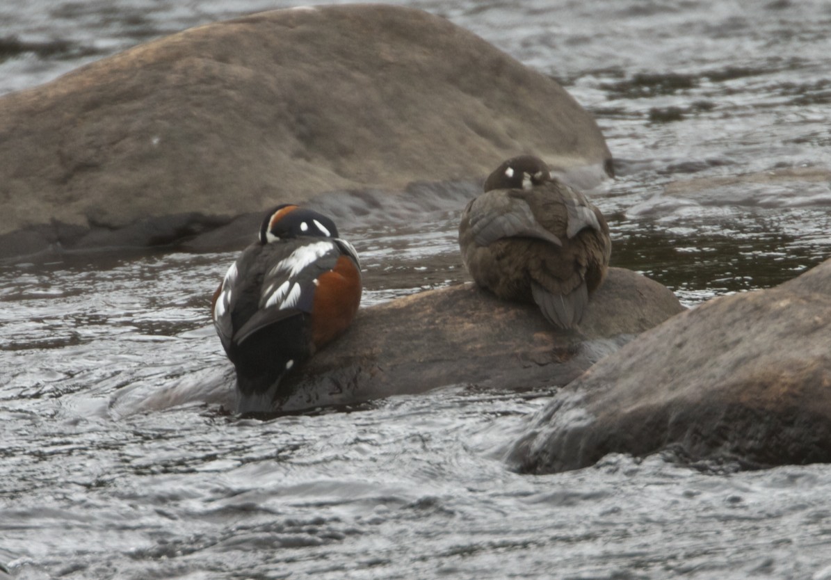
We detoured to the small fishing village of Conche’, set at the base of the extremely rugged and ragged cliffs that plunge 1000 feet from the Long Range down to the sea, often with magnificent braided waterfalls.  Moose were fairly common and much caution is advised when driving.  Check the roadside ponds and pools as well - we saw breeding pairs of Common Goldeneye, Ring-necked Ducks, and Common Loons.
DENNIS PILGRIM
Just off Route 432 south of the town of Main Brook is the rustically beautiful Tuckamore Lodge (www.tuckamorelodge.com), comprised of several two-story log buildings for accommodations and dining.  Primarily used as an upscale base for hunters and fishermen, the lodge itself is exquisite in both its Scandanavian design and furnishings. The lodge fronts a tranquil lake, available for canoeing, kayaking and fishing, where nesting loons entertain with their eerie calls.  Unusual and ironic is that the Lodge was founded and built by a woman, Barb Genge, but caters almost exclusively to men.  Barb is trying to change this profile by offering a women-only fly-fishing week, which will cater to both the experienced and novices alike.  You couldn’t imagine a better place to do it.  In fact, I decided to spend a cold, wet, windy morning with Dennis Pilgrim, local resident and guide, seeking out native brook trout with my 5-weight Sage fly rod.  We bounced along old rutted logging roads, deeper and deeper into the bush, until Dennis announced, “This ‘ere’s where we’re gettin’ hoot.”  Duh yeh mind walkin’ a bit?”  Sometimes, it wasn’t easy understanding Dennis, with his thick northern Newfie brogue.  The local patois drops the H’s, and adds them to every word starting with a vowel.  As in, “The hairport is height miles nort, hat St. Hanthony, aboot a turty minute drive, if hit’s na rainin’.”  On the other hand, how much do you need to understand when you’re goin’ a troutin’?  
DENNIS FLY-CASTING AT BROUSEY HOLE
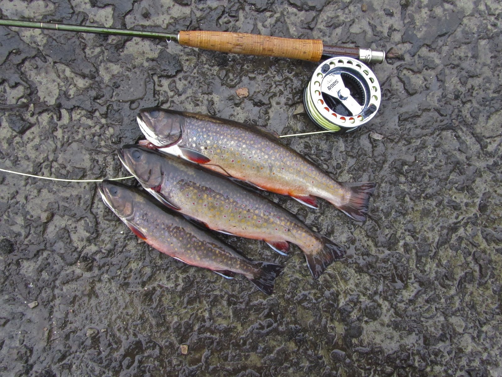
A TRIO OF BROOK TROUT FOR THE PAN
We walked about a mile through the bush to the Brousey Hole, a small river that appears, rapidly descends through a series of trout-filled rapids through a broad meadow and then disappears between two cleft rocks, continuing its ultimate course to the sea underground. This is both geology and hydrology with which New Englanders have little familiarity.  Ahhh, but the fish!  We worked the riffles and pools below each rapid and I managed to land 15 beautifully speckled brook trout, ranging from 6-14 inches in length, in about two hours.  Each fish is so magnificently colored with blue and red spots, flaming orange belly and white-lined fins on a chrome-beige background, that it’s like a work of art.  We kept five for lunch, which the cooks at the lodge were happy to add to the menu.  Great salmon fishing is also available nearby starting near the end of June.
We pushed further north to L’Anse aux Meadows, site of the Viking colony that existed for several years on the very northern tip of Newfoundland 1000 years ago.  Once again, the site is beautifully developed with a new interpretive center, recreated sod huts equipped with all the gear the Vikings may have had in those days.  After playing with very heavy and cold swords, helmets and shields, putting furs around our shoulders and talking with the guide dressed in ancient Norse costume, we walked a short trail where the actual village remains were archaeologically explored and then reinterred.  The area was several degrees warmer then, with higher sea levels, making it much more habitable than it is at present.  The stories of Leif Erikson, son of Erik the Red, who led the Vikings in this quest, were orally passed down for 300 years in the Icelandic Sagas before being committed to writing.  Standing where they stood a millennium ago on these barren shores, looking out to sea as spring icebergs float by, it is hard to imagine these ancient sailors eking out a life here.  On the rockweed covered shore, a group of four hen common eiders escorted their just hatched downy ducklings to the water for their first visit to the sea.  Some things haven’t changed in 1000 years.
We returned to the west coast and drove south to the town of St. Barbe, where we hoped to sail across the Strait of Belle Isle to Labrador.  We arrived to see people stacked up like cordwood at the terminal, waiting to see if the ferry would sail today.  High winds had caused cancellation of yesterday’s trips and today’s were cancelled as well.  Perhaps tomorrow morning, the stormy weather would abate and we all could safely make the crossing.
Perhaps not.  After delays, announcements, more delays, more announcements, we anxiously boarded the ferry at 6:00 PM.  It was raining, cold and windy.  The winds had been ferocious all day.  Would we be able to dock on the other side, where the wind was at its worst?  More importantly, would we toss our Newfoundland cookies?
To be continued...
Questions?  Write sam.fried@live.com